MRBC Award Winning Organization
NATIONAL RECOGNITION
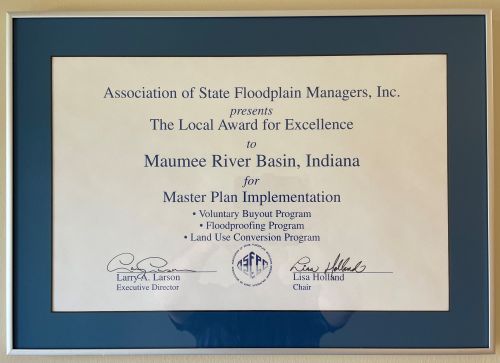
The Local Award For Excellence seeks to recognize outstanding programs or activities at the front lines of floodplain management, where true success or failure rests. Local entities include local units of government such as cites, towns, counties, and regional river basin commissions. Maumee River Basin Commission was presented the "Local Award for Excellence" from the national ASSOCIATION OF STATE FLOODPLAIN MANAGERS on May 26, 1999 in Portland, Oregon. "MAUMEE RIVER BASIN COMMISSION, INDIANA" is being recognized for their effective and proactive leadership efforts in floodplain management. Of particular note is the way they implement their Master Plan, which encompasses nonstructural mitigation activities such as voluntary buyouts, floodproofing, and agricultural areas land-use conversion programs.
STATE RECOGNITION
EXCELLENCE IN FLOODPLAIN MANAGEMENT AWARD
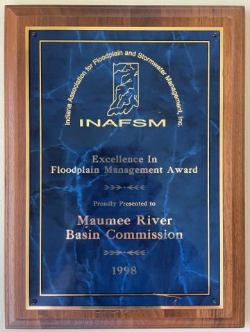
Established in 1997, this award recognizes an outstanding floodplain management program or an outstanding floodplain manager. This award may be bestowed annually upon a local unit of government or an individual, affiliated with the state or a local government, who has consistently demonstrated leadership in the area of floodplain management and has instituted a pro-active approach consistent with the INAFSM vision of sound water resources management in the State of Indiana. Maumee River Basin Commission is being recognized for its leadership in proactive floodplain management, implementation of higher standards Flood Hazard Area Ordinances and Storm Water & Erosion Control Ordinances
OUTSTANDING FLOODPLAIN MANAGEMENT PROJECT AWARD
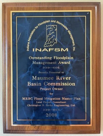
Established in 1998, this award recognizes an outstanding floodplain project studied, designed, or constructed by a firm for a local unit of government or a private entity. This award may be bestowed annually upon both the “representing firm” and the “project owner”. Maumee River Basin Commission is being recognized for its stellar Flood Mitigation Master Plan which was recently updated to include an online mapping tool powered by esri. The online mapping tool allows viewers to quickly determine where high, medium, and low priority mitigation recommendations are located and where successful mitigation measures have already taken place. The online mapping tool is a great resource for preparing FEMA Grant applications.
EXCELLENCE IN FLOODPLAIN MANAGEMENT AWARD
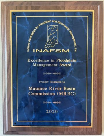
Established in 1997, this award recognizes an outstanding floodplain management program or an outstanding floodplain manager. This award may be bestowed annually upon a local unit of government or an individual, affiliated with the state or a local government, who has consistently demonstrated leadership in the area of floodplain management and has instituted a pro-active approach consistent with the INAFSM vision of sound water resources management in the State of Indiana. Maumee River Basin Commission is being recognized for its leadership in proactive floodplain management, implementation of a comprehensive Flood Acquisition Program and for their tireless education and outreach efforts promoting Flood Safety Awareness and the purchase of Flood Insurance.
|
The Maumee River Basin Commission’s Flood Mitigation Master Plan was nominated for the Outstanding Floodplain Project Award in recognition of its use of “cutting edge” technology, its web-based design and its commitment to aggressively promoting “No Adverse Impact” initiatives for reducing flood-damages and improving water quality throughout the six counties in northeastern Indiana. The Master Plan does an excellent job of reviewing the Commission’s 1995 Master Plan, evaluating the progress MRBC has made over the past 13 years and looking ahead to tomorrow’s challenges which are addressed in the Master Plan recommendations section. The Master Plan’s web-based design allows access to virtually anyone with access to a computer and more importantly, allows the plan to remain current with updates being made on a semi-annual basis. Some of the key hi-lights include:
|