CHAPTER II
DESCRIPTION & TRENDS IN THE WATERSHED
INTRODUCTION
Becoming aware of trends, such as population fluctuations, land use changes, economic diversity, and program development can provide insight regarding the watershed’s current situation. This information may also assist in the development of strategies to incorporate future trends while reducing the impact to water quality and water quantity. The flooding section found below provides details for recent flooding events within the Maumee River Basin and where possible, describes those events in specific locations and neighborhoods. Later sections will describe the trends regarding population, areas of growth and development, and local economic situations. This information provides the background justification for long term planning and program development designed to reduce the economic impact from flooding events as well as water quality degradation in the affected areas, including downstream reaches.
SOCIAL, PHYSICAL, & ECONOMIC CHANGES WITHIN THE MAUMEE RIVER BASIN
POPULATION
It is important to understand population trends as this information helps to direct various funding sources, create political boundaries, and guide long term planning efforts. As municipalities experience growth, the need increases for expansion of infrastructure such as roads and sewer services; public protection efforts such as fire and police forces; and property protection efforts through coordinated and planned development. Drinking water, wastewater treatment, and natural waterways can become taxed with unplanned or undirected growth due to increased demands for potable water, sewage treatment, and developable land typically increases with population.Information such as recent population growth, estimated future populations, and the main population centers in each of the counties within the Maumee River Basin are presented in a comparative format below. More detailed information regarding population trends and analysis can be found at STATS Indiana which provides information on the State of Indiana and individual counties.
Population Statistics for the Maumee River Basin
(STATS Indiana, 2008)
|
Adams |
Allen |
DeKalb |
Noble |
Steuben |
Rank in State |
46 |
3 |
35 |
29 |
8 |
1990-2000 Growth |
8.1% |
10.3% |
14.0% |
22.2% |
21.0% |
2006 Population |
33,719 |
347,316 |
41,902 |
47,918 |
33,683 |
2010 Population (Estimated) |
33,458 |
346,653 |
41,993 |
47,627 |
34,122 |
Populous areas in MRB |
Decatur |
Fort Wayne |
Auburn |
Avilla |
Clear Lake |
ECONOMICS
Understanding the overall economic situation with the Maumee River Basin is also important as the MRBC develops cost share programs related to property acquisitions and floodproofing. Median income, poverty rates, and unemployment rates may also provide important insight regarding the ability for individual homeowners and municipalities to participate in water quantity and water quality protection efforts. Areas where the median household incomes are low and poverty rates are high may prioritize their funding and staffing efforts differently than areas with higher median household incomes and lower poverty rates. These areas may not have the ability to perform upgrades to water treatment facilities designed to discharge properly treated wastewater, extension of sanitary sewers to reduce the number of residential septic systems, or complete detailed flood studies of streams and waterways to better identify floodplains. Areas without such situations may be able to perform those upgrades, extensions, and detailed studies much easier.
Economics in the Maumee River Basin
(STATS Indiana, 2008)
|
Adams |
Allen |
DeKalb |
Noble |
Steuben |
Median Household Income (2004) |
$43,781 |
$42,867 |
$46,930 |
$44,255 |
$43,032 |
Poverty Rate (2004) |
10.1% |
11.3% |
8.3% |
8.7% |
9.0% |
Resident Labor Force (2006) |
16,398 |
184,398 |
21,767 |
23,930 |
16,793 |
Unemployment (Dec. 2007) |
4.2 |
4.7 |
5.1 |
5.6 |
6.2 |
Major Employment Categories |
Manufac: 33% |
Other: 22% |
Manufac: 42% |
Manufac: 39% |
Manufac: 32% |
Land Use
As shifts in populations and economics occur, it can be anticipated that land use will also shift. New development and land use change can serve as a predictor of future water quality and quantity problems. These may include:
- Areas of planned development (construction activities)
- Increased sedimentation
- Increased nutrient loadings
- Areas of development lacking sanitary sewers
- Increased bacteria and pathogens
- Increased nutrient loadings
- Areas of planned Commercial or Industrial development
- Increased heavy metal loadings
- Increased air pollution (precipitates to surface waters)
- Increased impervious surfaces
- Increases in impervious surfaces such as roads, parking lots, and rooftops
- Increased volume and velocity of stormwater runoff
- Shifted peak discharges and times of concentration
- Increased temperature of stormwater runoff
- Increased streambank erosion and habitat degradation
A change in land use may also be beneficial to the water quality and quantity within the watershed. For example, historically agricultural land use converted to open space or a conservation easement may reduce pollutant loadings and may also serve as a floodplain to reduce the damaging effects from flood events.
Overall, within the Maumee River Basin the shift has been from a predominantly agricultural land use to a more residential and commercial land use in many of the populated areas. For this reason, many communities have completed Comprehensive Plans identifying these changes and highlighting areas best suited for future growth and development, as well as those best suited for conservation and protection of natural areas.
Adams County
According to the Adams County Planning Department, the most recent Comprehensive Land Use Plan was developed in April of 1994 and is not available electronically. Intended as a means to establish a “sound, flexible approach to land use decision-making in Adams County”, the plan indicates that growth will be directed within areas designated as “Urban Services Areas”; areas where needed infrastructure already exists or can be easily extended. Four such areas have been identified and are synonymous with the incorporated areas of Decatur, Berne, Geneva (outside of the Maumee River Basin), and Monroe. “Rural Service Areas” have also been identified as the unincorporated portions of Adams County and development requiring extension of utility and infrastructure will be discouraged in these areas.
The Comprehensive Plan also indicates the importance of:
- Encouraging development to protect the natural features of the site
- Promoting the protection of the County’s groundwater resources
- Promoting the preservation of the County’s wetlands
- Encouraging development proposals to provide setbacks from rivers and creeks
- Promoting adequate stormwater management facilities to serve the County
- Promoting practices that minimize the likelihood of flood damage within the County
- Preserve corridors along rivers and streams for future flood control projects
- Considering input from the MRBC when reviewing development proposals
[attempting to obtain maps for Adams County, Decatur, and
Berne in regard to planned growth areas]
More information can be obtained from the following websites:
Allen County / City of Ft. Wayne
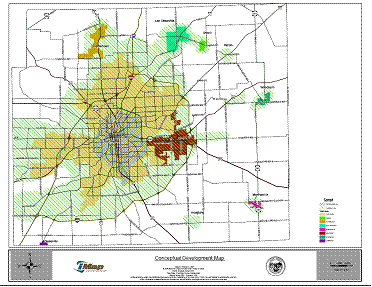 In January of 2007, a draft of the Allen County/City of Fort Wayne Comprehensive Plan was completed. Within this plan, detailed information can be found regarding projections for population growth and the needed development to serve the increased population in the categories of residential, commercial, and industrial land uses. It is estimated that with these projections additional acreage needed is 22,500 acres (12,108 residential acres; 8,000 commercial acres; and 2,400 industrial acres). Further, the development area is expected to occur within the Interstate 469 “loop” primarily to the south and west of the City of Ft. Wayne. It is also anticipated that development will create connections between the City of Ft. Wayne, the Town of Huntertown, and the Town of Leo-Cedarville.
Land use and the protection of natural features are discussed within the Comprehensive Plan provide such recommendations as:
- Encourage development that is sensitive to natural areas such as parks, wetlands, floodways.
- Identify and implement additional floodplain and watershed management tools.
- Inform and educate the public about conserving natural features and preserving sensitive areas.
- Collaborate with non-governmental organizations (NGOs) to acquire and/or protect natural and sensitive areas.
More information regarding the Allen County/City of Ft. Wayne Comprehensive Plan can be found by visiting the Allen County Comprehensive Plan Webpage. Also, information regarding the Allen County and City of Fort Wayne’s Department of Planning Services can be obtained at the website of the Department of Planning Services.
DeKalb County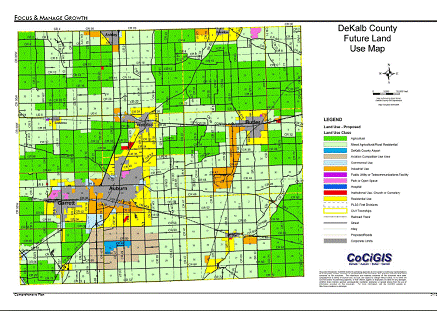
It is anticipated that future growth rates regarding both population and development will continue current trends and increase steadily over the years, especially as the City of Ft. Wayne and Allen County continue to expand and develop. DeKalb County has stated that they intend to manage growth in order to maintain the small town atmosphere and rural character of the county. Further, development will be encouraged in and around cities and towns to avoid the expense of extending public services and infrastructure. With this plan in mind, residential land use is expected to increase within the 2 mile perimeter of Auburn, Garrett, and Waterloo creating a larger, connected urban area. The perimeter of Butler and Hamilton are also anticipated to show an increase in residential land use.
Chapter 5, Protecting Environmental Assets, of the DeKalb County Comprehensive Plan includes the following objectives:
- Protect the quality and quantity of the County’s aquifers, stream, and rivers
- Discourage development within floodplains, wetlands, and riparian corridors
- Reduce damage to life and property from flood and other natural hazards by not allowing loss of storage within the floodplain and not allowing development to occur within the floodway.
More information can be obtained from the following websites:
- DeKalb County Plan Commission
- City of Auburn Building, Planning, and Development
- City of Butler Community Development, Planning, and Zoning
- City of Garrett Codes and Services
Noble County
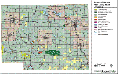
Projecting needs and determining the location of future land uses is one of the purposes of the Noble County Comprehensive Plan developed in 2006. Similar to the other Comprehensive Plans previously discussed, the intent is to focus future growth and development to the 2 mile radius of the towns and cities in Noble County. While very little of Noble County lies within the Maumee River Basin, it can be anticipated that growth within Kendallville and the areas southward toward Avilla will have an impact on the Maumee River and tributary streams.
- City of Berne
- City of Decatur
- Town of Monroe
- City of Auburn
- City of Butler
- City of Garrett
- Town of St. Joe
- Town of Waterloo
- City of Ft. Wayne
- Town of Grabill
- Town of Huntertown
- Town of Leo-Cedarville
- Town of Monroeville
- City of New Haven
- City of Woodburn
- Noble County
- Town of Clear Lake
- Town of Hamilton
- Reduce flood losses;
- Facilitate accurate insurance rating; and
- Promote the awareness of flood insurance.
- Public Information,
- Mapping and Regulations,
- Flood Damage Reduction, and
- Flood Preparedness.
- City of Berne
- City of Decatur
- Town of Monroe
- DeKalb County
- City of Auburn
- City of Butler
- Town of St. Joe
- Town of Waterloo
- City of Ft. Wayne
- Town of Grabill
- Town of Huntertown
- Town of Leo-Cedarville
- Town of Monroeville
- City of New Haven
- City of Woodburn
- Noble County
- Town of Hamilton
- Allen County MHMP (13 MB)
- Adams County MHMP (7 MB)
- DeKalb County MHMP (8 MB)
- Noble County MHMP (7 MB)
- Steuben County MHMP (9 MB)
- City of Berne
- City of Decatur
- Town of Monroe
- City of Auburn
- City of Butler
- City of Garrett
- Town of St. Joe
- Town of Waterloo
- City of Ft. Wayne
- Town of Grabill
- Town of Huntertown
- Town of Leo-Cedarville
- Town of Monroeville
- City of New Haven
- City of Woodburn
- Town of Clear Lake
- Town of Hamilton
- Identify Quality Limited Waters - States must identify and prepare a list of waters that do not or are not expected to meet water quality standards after applying existing required controls (e.g. minimum sewage treatment technology).
- Establish Priority Waters/Watersheds - States must prioritize waters/watersheds and target high priority waters/watersheds for TMDL development.
- Develop TMDLs - For listed waters, States must develop TMDLs that will achieve water quality standards, allowing for seasonal variations and an appropriate margin of safety. A TMDL is a quantitative assessment of water quality problems, contributing sources, and load reductions or control actions needed to restore and protect individual water bodies.
- To be able to use grant funds to leverage existing programs
- To provide the partners with a tangible success story
- To make it easier to obtain grant funds
- To empower the local community to create change
- To enable the community to get additional agency support
- To provide a way to track progress with measurable results
- To help the project grow bigger and last longer
- To inform the community, and market the project to new partners
- To record the group’s decisions
- To improve the quality of life for people in the watershed by helping ensure clean water and healthy natural resources
- Full body recreational contact is supported year round.
- Fish consumption advisories are eliminated.
- Stakeholders will maintain economic viability while giving full consideration to the environment
- Increases in bio-diversity, recreational activities, and aesthetics for the wildlife and stakeholders.
- Economic and ecologic drainage maintenance and improvement for agriculture, development, and flood control.
- Upper and Lower Cedar Creek
- Lower St. Joseph
- Bear Creek (IN)
- Development of a GIS based natural resource inventory
- Water quality monitoring
- Development and implementation of a cost share program
- Development of an education and outreach program
- Investigations to determine what problems are affecting a lake/lakes or a stream segment.
- Evaluation of identified problems and effective action recommendations to resolve those problems.
- Cost-sharing with land users in a watershed above upstream from a project lake or stream for installation or application of sediment and nutrient reducing practices on their land.
- Matching federal funds for qualifying projects.
- Watershed management plan development.
- Feasibility studies to define appropriate lake and stream remediation measures.
- Engineering designs and construction of remedial measures.
- Water quality monitoring of public lakes.
- Management of invasive aquatic vegetation
- Sediment removal from qualifying lakes.
-
Construction/Land Disturbance Storm Water Permitting (327 IAC 15-5, Rule 5)
IDEM administers a General Permit program that targets construction activities that result in land disturbance of one acre or more. These permits are applicable to a variety of projects including, but not limited, to residential, commercial, institutional, industrial, public, and special land uses.
327 IAC 15-5 is a performance-based regulation designed to reduce pollutants, principally sediment, that are a result of soil erosion and other activities associated with construction and/or land disturbing activities. (See Rule 5 explained at IDEM Site) -
Industrial Storm Water Permitting (327 IAC 15-6, Rule 6)
IDEM administers a general permit program that targets storm water runoff associated with industrial activities. Requirements of this rule apply to specific categorical industrial facilities, which are exposed to storm water and have a point source discharge of storm water from the industrial activities. Facility managers are required to submit a Notice of Intent and implement a storm water pollution prevention plan to address the discharge of pollutants associated with storm water runoff from their facility.
(See Rule 6 explained at IDEM Site) -
Municipal Separate Storm Sewer Systems (327 IAC 15-13, Rule 13)
Under Phase II, Rule 13 was written to regulate most MS4 entities (cities, towns, universities, colleges, correctional facilities, hospitals, conservancy districts, homeowner's associations and military bases) located within mapped urbanized areas, as delineated by the U.S. Census Bureau, or, for those MS4 areas outside of urbanized areas, serving an urban population greater than 7,000 people. In addition to these generalized criteria, designation of MS4 entities is potentially determined by other factors, including population growth and documentation which indicates water quality impairment. The following table indicates those communities regulated under the MS4 program within the Maumee River basin as well as the MS4 Operator name, address, and Rule 13 permit number as found on IDEM’s website. (See Rule 13 explained at IDEM Site)MS4 Communities within the Maumee River Basin
Within the Comprehensive Plan it is noted that nearly 83% of respondents to the Community Values Survey believe that the natural and environmental features should be protected. With this in mind, the Plan states that this means minimizing development practices that encroach into or destroy these areas. Areas such as surface water protection areas and floodplains have been identified on the future land use map. For more specific information regarding the Noble County Comprehensive Plan, please view the Noble County Comprehensive Plan (> 8 Mb).
Steuben County
As team members in Steuben County Government, the Plan Commission plays a key role in creating and communicating the vision of the County and acts as the primary coordinating agency in the development, adoption, and implementation of the County's plans and policies relating to development and use of the land.
The Steuben County Plan Commission is responsible for the Steuben County Comprehensive Plan, and its implementation through the County Zoning Ordinance, the Subdivision Control Ordinance, and various policies and practices. Guided by the Comprehensive Plan, the Plan Commission controls the type, location, and timing of development in unincorporated Steuben County.
According to the Plan Director, the Comprehensive Plan contains an objective to reduce conflicts between growth and the environment. It also suggests implementing regulations for development in floodplains and on steep slopes. The document also provides a background section on the importance of floodplain management to minimize economic loss. For more specific information regarding the Steuben County Comprehensive Plan, please contact the Steuben County Plan Commission:
Clear Lake
The Town of Clear Lake within Steuben County and the Maumee River Basin completed their Comprehensive Plan in 2006 after much public input through surveys. Within this plan, objectives such as assisting with the preservation of natural areas around Clear Lake, protect sensitive areas such as wetlands, streams, and riparian corridors, and to preserve the high quality of water feeding the lake by minimizing negative impacts to the lake and feeder streams by development.More information regarding the Town of Clear Lake and their Comprehensive Plan can be located at Town of Clear Lake's website.
FLOODING
Stakeholders in the Maumee River basin have expressed great concern over the issue of flooding and the correlation between water quantity and water quality. Historic climate and disaster data does indicate a strong prevalence of high water events, carrying with them the ability to wash out valuable in-stream habitat, destruct streambanks, increase pollutant loadings to receiving waterbodies, and associated destruction of aquatic communities. Debris from infrastructure and buildings damaged by flood events, oils, grease, and toxins from submerged vehicles and septic systems, and common chemicals and solvents that are present in nearly every home and can all become mobile when flooding occurs. These mobilized pollutants can exacerbate property damages while also causing damage to water quality in the area.
The residents of the Maumee River basin have suffered from floods of the St Marys, St. Joseph, and Maumee Rivers since the area has been inhabited. Flooding in the basin may occur as a result of rapid spring thaws or significant accumulations of snow, heavy rainfall, river blockage from ice jams, or combinations of these factors. Floods in the Maumee River are intensified when the St. Joseph and St. Marys rivers reach peak flow at the same time. Some of the most recent and damaging floods are highlighted below. Much of the information has been obtained from the National Climatic Data Center.
RECENT FLOOD EVENTS
January 1993 Flood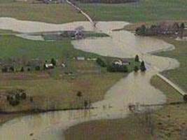
As recorded by the NCDC, extensive flooding occurred along several rivers in northern Indiana including the St. Joseph and surrounding many of the numerous lakes. Overall approximately 1,400 homes were affected. Snow cover of 3 – 5 inches melted quickly in late December and was followed by 2 – 3 inches of rain. An additional 1.5 – 2.5 inches of rain fell as the floodwaters began to subside. Floodwaters along the St. Joseph River reached their highest level since the flooding events that occurred in 1985. Steuben County was one of the hardest hit areas in the region. NCDC reported damages were $5.0 million over 9 counties.
June 2002 Flood
In Ft. Wayne, flash flooding of 4-6 inches of rain in 3 hours and some reports of 8+ inches in 3 hours resulted over 200 people were evacuated from homes and approximately 500 homes received flood damage;15 homes were condemned. Three businesses sustained major damage and a local car dealership reported damage beyond repair to 95 vehicles. Total property damage was reported by NCDC to be $5.0 million.
July 2003 Flood
Adams and Allen counties were severely affected by flooding as a result of flash flooding and ranges of 8 – 15 inches of rainfall in early July. Emergency Management reported damage to over 200 homes and 10 businesses  along with numerous public facilities along the St. Marys river in Decatur and Ft. Wayne. Later in July, over 4 inches of rain fell in the Spy Run Creek basin in 2-3 hours. Sandbagging efforts by local volunteers and National Guardsmen were prevalent throughout the basin to protect properties from flood damages. While no specific monetary damages were reported in regard to crop losses and damages, reports in The Journal Gazette on July 9, 2003 described “…corn plants that traditionally are knee high by this time of year are partly or fully submerged. The situation is worse for soybeans…”. Within the City of Ft Wayne, the neighborhood of Lakeside along the Maumee River credited 20 years and $91 million worth of efforts to construct a 10-mile network of levees and dikes for being saved from flood damages. In other areas of Ft Wayne and Allen County, the Health Department offered free well water testing for residents whose wells were submerged during the flooding. As reported by the NCDC, property damages were estimated to be $16.5 million with Adams, Allen, and Wells Counties.
January 2005 Flood
Early January rain mixed with significant snow melt led to prolonged flooding throughout the Maumee River Basin and the St Marys River threatened many areas within Decatur and Ft Wayne. The initial flood warnings expired and flood waters began to recede by January 9th but as additional rain was forecasted, sandbagging efforts continued and property owners and response agencies remained on alert. Residents along Junk Ditch, Spy Run, St Marys River, and the Maumee River sought emergency shelter, moved possessions to higher levels, and utilized sandbags and pumps as flood water rose quickly, up 1.3 feet in 6 hours as reported in The Journal Gazette. The St Marys River in Ft Wayne crested Friday, January 11th at just over 19 feet, less than the expected 21.4 feet which would have exceeded the record set in July of 2003 (21.2 ft). As a result of the event, several families had to leave their homes, over 80,000 sandbags were utilized, 1,000 truckloads of clay were used to construct emergency levees, and approximately 1,000 volunteers assisted with flood protection efforts. Final property damage estimates were not provided for this event.
Winter 2008 Flood
The most recent flooding event affecting the Maumee River basin occurred in January and February of 2008. Flooding throughout 21 counties in Indiana resulted in more than $10 million in disaster grants and loans following a Presidential disaster declaration. Within the Maumee River basin applications for assistance were made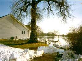 by 80 Allen County residents, 12 within DeKalb County, 19 within Noble County. Damages were less than those reported as a result of the 2003 flood and it was reportedly due to the number of homes in high risk areas that were bought out through grant and loan programs as well as increases in technology which provides a greater warning time and more efficient information transfer. As reported in the Journal Gazette, within the City of Decatur the St Marys River reached 23.5 feet on February 8th and was expected to crest at 24.5 feet the following day. Flood stage is reported to be 17 feet. Final damage estimates are not yet available.
Within Allen County, the City of Ft. Wayne, and throughout the Maumee River basin, numerous other flood and flash flood events have been reported to the NCDC. However, no associated monetary property or crop damages were provided. Brief damage descriptions included information such as various street closures and sandbagging efforts.
As population and development continues to increase within all areas of the Maumee River Basin, it can be anticipated that flood damages will increase. However, protective measures such as Flood Insurance Studies, Floodplain Ordinances, and the MRBC buy-out and floodproofing programs help to greatly reduce property damages associated with flood events. These programs will be discussed in greater detail in future sections of this plan.
FLOOD INSURANCE
Information gathered regarding flood insurance premiums and claims since 1978 indicates that Allen County, and more specifically the City of Ft Wayne has received the largest amount of claims disbursements as nearly $8.9 million over 1,262 claims. Following the City of Ft. Wayne is the remainder of Allen County with 146 claims since 1978 and payouts reaching $1.0 million. Information provide in the below indicates the total premiums, number of policies, claims, and payments for Adams, Allen, and DeKalb Counties and individual NFIP communities. In areas where no claims or premiums were made or held, information is not included within this table. Further, as minor portions of Noble and Steuben Counties lie within the Maumee River Basin, information is not reported for these areas.
Flood Insurance Premiums, Policies, Claims, and Disbursements in the
Maumee River Basin: Adams, Allen, and DeKalb Counties
|
Premiums |
Policies |
Claims since 1978 |
Total Payments |
ADAMS COUNTY |
$9.7K |
24 |
13 |
$49.2K |
Berne |
$631 |
2 |
6 |
$200.8K |
Decatur |
$24.8K |
47 |
72 |
$893.7K |
ALLEN COUNTY |
$119.0K |
220 |
146 |
$901.5K |
Ft Wayne |
$698.4K |
1,000 |
1,262 |
$8.9M |
Huntertown |
$656 |
2 |
0 |
$0 |
Leo-Cedarville |
$733 |
2 |
0 |
$0 |
Monroeville |
$5.4K |
6 |
0 |
$0 |
New Haven |
$20.3K |
31 |
17 |
$57.1K |
Woodburn |
$264 |
1 |
0 |
$0 |
DEKALB COUNTY |
$15.7K |
29 |
8 |
$19.7K |
Auburn |
$33.2K |
47 |
21 |
$267.2K |
Butler |
$2.8K |
6 |
0 |
$0 |
Garrett |
$452 |
2 |
1 |
$0 |
Waterloo |
$5.0K |
2 |
2 |
$219 |
(K=1,000; M=1,000,000)
NATIONAL FLOOD INSURANCE PROGRAM (NFIP)
The U.S. Congress established the National Flood Insurance Program (NFIP) with the passage of the National Flood Insurance Act of 1968. The NFIP is a Federal program enabling property owners in participating communities to purchase insurance as a protection against flood losses in exchange for State and community floodplain management regulations that reduce future flood damages. Participation in the NFIP is based on an agreement between communities and the Federal Government. If a community adopts and enforces a floodplain management ordinance to reduce future flood risk to new construction in floodplains, the Federal Government will make flood insurance available within the community as a financial protection against flood losses. This insurance is designed to provide an insurance alternative to disaster assistance to reduce the escalating costs of repairing damage to buildings and their contents caused by floods.
In addition to providing flood insurance and reducing flood damages through floodplain management regulations, the NFIP identifies and maps the Nation’s floodplains. Mapping flood hazards creates broad-based awareness of the flood hazards and provides the data needed for floodplain management programs and to actuarially rate new construction for flood insurance.
Funding for the NFIP is through the National Flood Insurance Fund, which was established in the Treasury by the 1968 Act. Premiums collected are deposited into the fund, and losses, and operating and administrative costs are paid out of the fund. In addition, the Program has the authority to borrow up to $1.5 billion from the Treasury, which must be repaid along with interest. Until 1986, Federal salaries and program expenses, as well as the costs associated with flood hazard mapping and floodplain management were paid by an annual appropriation from Congress. From 1987 to 1990, Congress required the Program to pay these expenses out of premium dollars. When expressed in current dollars, $485 million of policyholder premiums were transferred to pay salary and other expenses of the Program. Beginning in 1991, a Federal policy fee of $25 dollars, which was increased to $30 in 1995, is applied to most policies in order to generate the funds for salaries, expenses, and mitigation costs.
The three basic components of the Program – identifying and mapping flood-prone communities, the requirement that communities adopt and enforce floodplain management regulations, and the provision of flood insurance – are described in detail below. Other aspects and components of the Program, including the Mandatory Purchase Requirement, the Community Rating System and the Flood Mitigation Assistance program, are also described.
NFIP Communities within the Maumee River Basin include:
Adams County |
DeKalb County |
Allen County |
Noble County Steuben County |
For more information regarding the NFIP program please visit: http://www.fema.gov/business/nfip/
COMMUNITY RATING SYSTEM (CRS)
The National Flood Insurance Program's (NFIP) Community Rating System (CRS) is a voluntary incentive program that recognizes and encourages community floodplain management activities that exceed the minimum NFIP requirements. As a result, flood insurance premium rates are discounted to reflect the reduced flood risk resulting from the community actions meeting the three goals of the CRS:
For CRS participating communities, flood insurance premium rates are discounted in increments of 5%; i.e., a Class 1 community would receive a 45% premium discount, while a Class 9 community would receive a 5% discount (a Class 10 is not participating in the CRS and receives no discount). The CRS classes for local communities are based on 18 creditable activities, organized under four categories:
Within the Maumee River Basin, the City of Decatur and the City of Ft. Wayne are currently at a Class 8 which allows for a 10% discount on flood insurance premium rates. Allen County is currently at a Class 9, which allows for a 5% discount on flood insurance premium rates. More information regarding the CRS program can be located at FEMA's Website.
FLOODPLAIN MANAGEMENT ORDINANCES
Flood Hazard Areas Ordinances have been adopted by all NFIP communities as part of the NFIP requirements. Optional provisions have been established as part of the State of Indiana’s Model Ordinance for Flood Hazard Areas. These provisions, when adopted, require that when any portion of the Special Flood Hazard Area (SFHA) is authorized for use, the volume of space that will be occupied by the authorized fill or structure below the Base Flood Elevation (BFE) shall be compensated for and balanced by an equivalent volume of excavation taken below the BFE. The excavation volume must be equal to the volume of storage lost (or a replacement ratio of 1 to 1) due to the fill or structure. In 1995, the MRBC Flood Control Masterplan recommended adoption of compensatory storage provisions by all communities in the Maumee River Basin.
This additional language has been adopted by:
Adams County |
DeKalb County |
Allen County |
Noble County Steuben County |
With the optional language added, these ordinances will be an effective method to control development activity within outlined floodplains by prohibiting development unless it has been deemed a permitted use, such as agriculture, parks or roadways, or the proposed development is considered a special use, such as a public well, golf course, or sewage treatment plant. These ordinances would require measures to be taken to prevent increased damages by outlining that no development activities within the flood hazard area may increase the flood height or velocity.
DISASTER MITIGATION ACT OF 2000 (DMA 2000)
The development of a Multi-Hazard Mitigation Plan (MHMP) is a requirement of the Federal Disaster Mitigation Act of 2000 (DMA 2000). According to DMA 2000, the purpose of mitigation planning is for State, local, and Indian tribal governments to identify the natural hazards that impact them, to identify actions and activities to reduce any losses from those hazards, and to establish a coordinated process to implement the plan, taking advantage of a wide range of resources.
In order for National Flood Insurance Program (NFIP) communities to be eligible for future mitigation funds, they must adopt either their own MHMP or participate in the development of a multi-jurisdictional MHMP. The Indiana Department of Homeland Security (IDHS) and the Federal Emergency Management Agency (FEMA) Region V offices administer the MHMP program in Indiana.
The development of MHMPs is the necessary first step of a multi-step process to implement programs, policies, and projects to mitigate the effect of hazards in Counties and NFIP communities. The intent of these planning efforts is to identify the hazards such as flooding and dam failure, and the extent that they affect specific areas, and to formulate mitigation strategies or projects that could be undertaken to mitigate for these hazards. Although MHMPs may meet the requirements of DMA 2000 and eligibility requirements of the Hazard Mitigation Grant Program (HMGP), Flood Mitigation Assistance (FMA), Pre-Disaster Mitigation (PDM) Grant, as well as other FEMA programs including the NFIP Community Ratings System (CRS), additional detailed studies will need to be completed prior to applying for these grants or programs.
Funding to prepare MHMPs for the Counties and NFIP communities within the Maumee River Basin was made available through PDM grants awarded to the respective County Commissioners by FEMA. The required 25% local match contribution was provided by the MRBC in the form of grants awarded to the County Commissioners. Christopher B. Burke Engineering, Ltd. (CBBEL) was hired to facilitate the planning process and prepare the MHMPs under the leadership of a Certified Planner through the American Institute of Certified Planners (AICP).
To view the individual county's MHMP, click on the links below:
The following is a listing of participating counties and communities within the Maumee River Basin with approved MHMPs:
Adams County - Adams County EMA |
DeKalb County - DeKalb County EMA |
Allen County - Allen County EMA |
Noble County - Noble County EMA Steuben County - Steuben County EMA |
WATER QUALITY
STATEWIDE STUDIES
2006 Indiana Integrated Water Quality Report
The IDEM is the primary agency involved in surface water quality monitoring and assessment in the State of Indiana. In conjunction with the requirements of the Clean Water Act (CWA) and the State’s goals for protecting its natural and recreational resources, the IDEM operates several monitoring programs designed to monitor and assess the chemical, physical, and biological conditions of Indiana’s rivers, streams, and lakes.
The IDEM’s Office of Water Quality’s surface water quality basin strategy is designed to describe the overall environmental quality of each major river basin in the state and to identify monitored water bodies that do not fully support designated uses. The IDEM’s surface water monitoring was revised in 2001 to meet the goals of assessing all waters of the state within five years.
The 305(b) report provides a compilation and summary of all of the IDEM’s water quality monitoring and assessment data (compiled from AIMS database and other datasets/reports within the IDEM). Each subwatershed is given a water quality rating relative to its streams status in meeting Indiana’s Water Quality Standards (WQS). WQS are set at levels necessary for protecting a waterway’s designated use(s), such as swimmable, fishable, or drinkable. Each subwatershed is given a rating of fully, partially, or not supportive of its designated uses.
 Chapter 303(d) of the CWA requires states to identify waters that do not or are not expected to meet applicable water quality standards with technology based standards alone. States are also required to develop a priority ranking for these waters, taking into account the severity of the pollution and the designated use of the waters. Once this listing and ranking of waters is completed, States are required to develop TMDLs for these waters in order to achieve water quality standards. In an attempt to ensure greater consistencies between the 305(b) report and 303(d) list, the two reports are now submitted together as an integrated report to U.S. EPA every two years.
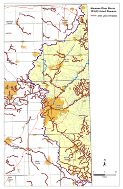
The streams and tributaries within the Maumee River Basin have been listed for various impairments. The primary impairments are E. coli, nutrients, impaired biotic communities, and algae as well as fish consumption advisories (FCA) for Polychlorinated Biphenyls (PCBs) and mercury. For specific impairments on individual stream segments, please visit IDEM's webpage.
Fish Consumption Advisory (FCA)
Each year since 1972, three agencies have collaborated to create the Indiana FCA. These agencies include the IDEM, the IDNR, and the Indiana State Department of Health (ISDH). Each year, members from these agencies meet to discuss the findings of recent fish monitoring data and to develop the new statewide fish consumption advisory.
The 2004 FCA is based on levels of Polychlorinated Biphenyls (PCBs) and mercury found in fish tissue. In each area, samples were taken of bottom-feeding fish, top-feeding fish, and fish feeding in between. Fish tissue samples were analyzed for PCBs, pesticides, and heavy metals. Of those samples, the majority contained some level of mercury. However, not all fish tissue samples had mercury at the levels considered harmful to human health. If the samples resulted in higher than normal levels of mercury, those waterbody segments were listed in the fish consumption advisory. There is a statewide FCA for carp in all Indiana streams, the Indiana portion of Lake Michigan, and inland lakes due to the bioaccumulation tendencies of PCBs. The table below indicates the FCA for streams within the Maumee River Basin. Groups refer to the frequency of meals of the associated species that may be safely consumed per week or per month; Group 1: unlimited meals; Group 2: 1 meal per week; Group 3: 1 meal per month; Group 4: 1 meal per 2 months; and Group 5: DO NOT EAT.
Fish Consumption Advisories, Maumee River Basin
Location |
Species |
Size (inches) |
Contaminant |
Group |
Maumee River |
Buffalo Bigmouth |
20+ |
PCBs |
3 |
Carp |
<20 |
PCBs |
4 |
|
20-22 |
PCBs |
5 |
||
Channel Catfish |
14-16 |
PCBs |
3 |
|
16+ |
PCBs |
4 |
||
Freshwater Drum |
All |
PCBs |
3 |
|
Largemouth Bass |
9+ |
PCBs |
3 |
|
River Redhorse |
12-14 |
PCBs |
3 |
|
14+ |
PCBs |
4 |
||
Rock Bass |
7-8 |
PCBs |
3 |
|
8+ |
PCBs |
4 |
||
Sauger |
24+ |
PCBs |
3 |
|
Shorthead Redhorse |
14-16 |
PCBs |
3 |
|
16+ |
PCBs |
3 |
||
Walleye |
<21 |
PCBs |
4 |
|
21+ |
PCBS |
5 |
||
St. Marys River |
Black Redhorse |
15+ |
PCBs |
3 |
Carp |
<20 |
PCBs |
3 |
|
20+ |
PCBs |
4 |
||
Channel Catfish |
13-15 |
PCBs |
3 |
|
15+ |
PCBs |
4 |
||
Largemouth Bass |
<15 |
PCBs |
3 |
|
15+ |
PCBs |
4 |
||
Silver Redhorse |
17+ |
PCBs |
3 |
|
White Sucker |
11+ |
PCBs |
3 |
|
Pigeon Creek |
Carp |
21-25 |
PCBs |
3 |
25+ |
PCBs |
4 |
Total Maximum Daily Loads (TMDL)
A TMDL is a tool for implementing water quality standards and is based on the relationship between pollutant sources and in-stream water quality conditions. The TMDL establishes the allowable loadings or other quantifiable parameters for a water body and thereby provides the basis to establish water quality-based controls. These controls should provide the pollutant reduction necessary for a water body to meet water quality standards.
The TMDL process provides a flexible assessment and planning framework for identifying load reductions or other actions needed to attain water quality standards (i.e. water quality goals to protect aquatic life, drinking water, and other water uses). The process has three steps:
States are responsible for implementing the TMDL process. EPA reviews and approves lists of quality-limited waters and specific TMDLs. If EPA disapproves lists or TMDLs, EPA is required to establish the lists and/or TMDLs. Landowners, other agencies, and other stakeholders can often assist States or EPA in developing TMDLs for specific watersheds.
To date, the only TMDL that has been completed within the Maumee River basin is for E. coli along the Maumee River in the St. Marys River watershed in Adams and Allen Counties. More information related to development of TMDLs and access to completed TMDLs can be found at http://www.in.gov/idem/4676.htm.
LOCAL WATERSHED PLANS
IDEM 319 Watershed Management Plans (WMPs)
According to the Indiana Department of Environmental Management’s (IDEM) watershed planning guidance – the Indiana Watershed Planning Guide – “Watershed planning connects the community’s decision-making to sensible data collection and defensible analysis. Recording those decisions in a watershed plan increases the probability that the problems will be addressed.” The top ten reasons for developing a WMP are:
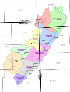
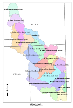
See Map of Local Watershed Groups in the Maumee River Basin
St Joseph River Watershed Initiative
According to the February 2006 St. Joseph River WMP, there are nine 11-digit Hydrologic Unit Code (HUC-11) areas that complete the larger 8-digit HUC (HUC-8) in the St. Joseph River watershed.
 The vision for the SJRWI includes key points with respect to water quality and quantity.
As outlined in the original WMP, efforts have been taken to complete individual WMPs for several sub-watersheds:
Further, The Nature Conservancy’s Upper St. Joseph River Project has focused on the Fish Creek watershed for several years.
St. Marys River (IN) Watershed Project
 The primary basis for the project is to complete a WMP for the Indiana portion (Adams, Allen, and Wells Counties) of the St. Marys River. Through public meetings and with the assistance of the Steering Committee the major pollutants have been identified as sediment, flooding, nutrients, and bacteria. Other tasks to be completed through this project include:
DNR Lake and River Enhancement (LARE)
The goal of the Division of Fish and Wildlife's Lake and River Enhancement Section is to protect and enhance aquatic habitat for fish and wildlife, to insure the continued viability of Indiana's publicly accessible lakes and streams for multiple uses, including recreational opportunities. This is accomplished through measures that reduce non-point sediment and nutrient pollution of surface waters to a level that meets or surpasses state water quality standards.
To accomplish this goal, the LARE Program provides technical and financial assistance for qualifying projects. Approved grant funding may be used for one or more of the following purposes:
LARE projects completed within the Maumee River Basin
Lake(s), or River Watershed Name |
Indiana County (or Counties) Location |
Project Report Name |
Date of Report (Month and Year) |
Ball |
Steuben |
January-03 |
|
Clear |
Steuben |
June-93 |
|
Hamilton |
Steuben |
Oct-06 |
|
Hamilton |
Steuben |
January-90 |
|
Hamilton |
Steuben |
Contract Documents for Wetland Enhancements to Improve the Water Quality of Hamilton Lake |
August-99 |
Hamilton |
Steuben |
November-91 |
|
Hamilton |
Steuben |
November-91 |
|
Hamilton |
Steuben |
Supporting Design Report for Wetland Development to Improve the Water Quality of Hamilton Lake |
September-99 |
Hamilton |
Steuben |
DRAFT 2007 Aquatic Plant Management Plan for Hamilton Lake in Steuben County, Indiana |
Dec-07 |
REGULATORY PROGRAMS
Storm Water Permitting
The emphasis of Indiana Department of Environmental Management (IDEM) storm water permits is water quality. Water quantity, while an integral part of storm water, is typically regulated through ordinances developed and implemented by local governmental entities. Following are three storm water permitting programs that are administered by IDEM and related information associated with urbanization and land development.
Entity Name |
MS4 Operator Title |
MS4 Operator Address |
Rule 13 Permit Number |
Board of County Commissioners President |
1 East Main Street, Rm 200 |
INR040131 |
|
Superintendent |
2010 South Wayne Street |
INR040119 |
|
City of Decatur |
Mayor |
City Hall |
INR040055 |
City of Fort Wayne, IU/PU-Fort Wayne, Ivy Tech State College-Northeast, Indiana Institute of Technology, University of Saint Francis |
Board of Public Works and Utilities Director |
480 City-County Building |
INR040029 |
(IDEM, 2008) http://www.in.gov/idem/4896.htm
SUMMARY
Each watershed, small or large, has unique characteristics and problem sets partially determined by demographics, natural resources, and the interactions of the two. By being cognizant of the trends regarding population growth, land use change, development patterns, policy implementation, and water quality decisions can be made that will promote organized development while allowing preservation of natural resources, protection of water quality, as well as mitigation of flood damages and risks. Policies and procedures such as ordinances, plan review, landowner assistance programs, and increased funding allocations are all methods to ensure water quality and water quantity are managed at the local level as well as basin wide.
![]()
Other Information
![]()
THIS SITE IS BEST VIEWED IN MICROSOFT INTERNET EXPLORER 6.0 OR HIGHER