CHAPTER III-4
FLOOD WARNING SYSTEM & RIVER GAGE PLACEMENT
INTRODUCTION
Gauges that measure the stage and discharge at given points along a stream form the backbone for Flood Warning Systems. These gauges provide historic data that aids the National Weather Service Forecast Center and Ohio River Forecast Center in predicting the time and height of flood crests. This information is in turn used by emergency management agencies and communities to plan their flood fight response efforts. Because of the ability to reduce flood damages by such forecast abilities, the National Flood Insurance Program (NFIP) gives credit for early flood warning systems in their Community Rating System (CRS). Fort Wayne, Allen County, and the City of Decatur participate in this program and each of their respective residents receives a reduction in their flood insurance premiums. Stream gauges are an important part of the flood warning system and should be funded at all times. This MRBC Master Plan update provides an opportunity for MRBC to document the flood warning systems that are in place in the basin and to evaluate additional possibilities for coordination among affected communities and enhancing the system for the benefit of all.
1995 MASTER PLAN REVISITED
A critical component of the flood warning systems in the Maumee River Basin is the network of rain, snow, and stream flow gauges. Information from theses gauges drives the whole process. Rain/snow gauges provide information on the extent of a given precipitation event. The larger area a significant rainfall covers, the larger the area that needs to be warned and the more significant the actions that need to be taken to prevent losses. Using the rainfall/snowfall gauges, the forecast center can provide warnings for appropriate areas, warning those affected as well as indicating where flood fighting resources do not need to be focused. A good coverage of rainfall gauges also provides information on the time distribution of the rainfall. Current radar technology used by the National Weather Service does not provide this information. This information is important for calibrating hydrologic models of the watershed for use in predicting future events. A complete stream gauge network is also important as the timing of rainfall over tributaries affects how the outflow from tributaries combines with the main stem. If peaks occur at similar times, then flooding would be expected to be worse than if the tributaries are peaking at different times.
In addition to the flood warning benefits, the gauge network also provides water quality benefits. Without stream flow quantity, water quality analyses can not provide pollutant loading information. If water quality sampling is done near a gauge, the presence of a stream gauge allows calculation of the concentration of the bacteria, pathogens, nutrients or sediment loading in the stream. This provides information for analysis of detrimental or beneficial land use changes or implementation of best management practices upstream of the gauging station and helps identify problem areas.
The 1995 Master Plan described the pieces of the flood warning system in place at the time and called for the consideration of improved flood warning systems for outlying communities such as Auburn and Decatur. At the time, the City of Fort Wayne, in cooperation with the Fort Wayne office of the National Weather Service (NWS), had a flood warning system which included the following eight river gauges.
St. Marys River:
- U.S. 27 bridge in Decatur, IN
- Anthony Boulevard bridge south of Fort Wayne
St. Joseph River:
- Newville, IN
- Roots Ski House, north of Fort Wayne
Spy Run Creek:
- Near Sherman Street bridge
Cedar Creek:
- Near Auburn Wastewater Treatment Plant
Maumee River:
- Anthony Street bridge in Fort Wayne
- Landin Road bridge near New Haven
The system was supplemented with the following ten rain gauges:
- Auburn, IN
- Newville, IN
- North of Fort Wayne, County Highway Department Building, Lima Road
- North of Fort Wayne, Resident's Home off of St. Joe Road
- Spy Run in Fort Wayne
- Anthony Blvd. bridge south of Fort Wayne
- Poe, IN
- Decatur, IN
- Salem, IN
- Rockford, OH
The office of the National Weather Service located at the Fort Wayne International Airport, in a cooperative effort with the City of Fort Wayne, monitored these gauges and developed forecasts for the elevation and timing of the expected flood crests. These two entities also cooperated in providing information on potential floods to the outlying communities.
During a flood, flood relief in the City of Fort Wayne was coordinated by an Emergency Operation Center set up through a coordinated effort between the various City departments. The need to set up this center was triggered by the stream gauge network, specifically the Anthony Street gauge on the Maumee River. When it reached 19.0 feet, personnel from the City were assigned to various regions and were required to monitor levee conditions, flood elevations, and potential damage areas. These personnel were also responsible to coordinate the relief efforts in their respective regions.
Flood relief in Adams, DeKalb, Noble, and Steuben counties depended on the Civil Defense Emergency Management departments in the respective counties to coordinate the needed efforts.
Because of the benefits realized by effective early flood warning systems in reducing potential flood damages in the Basin, the 1995 Master Plan recommended that continued upgrading of the early warning system in Fort Wayne and the outlying communities be studied further as a Master Plan Component.
MRBC ACCOMPLISHMENTS
Since the 1995 Master Plan, the flood warning network has undergone several changes including additions to the stream and rain gauge networks and an increase in available technology.
The following stream gauges have been added to the network.
- St. Marys River - Rockford, OH gauge installed in 2007
- Spy Run Creek - New gauge installed near Franke Park Zoo in 2007 to replace the gauge near the Sherman Street bridge
- Maumee River - Coliseum Blvd bridge in Fort Wayne
With the addition of the Rockford, OH gauge on the St. Marys River, the City of Fort Wayne has increased its early warning capabilities by an additional 24-30 hrs and its flood-crest prediction accuracy due to the ability to monitor stream flows upstream of Decatur, IN. This gauge has improved early warning capabilities for the City of Decatur as well.
Rainfall and/or snowfall gauges have also been added to the network. There are now 31 gauges used in the network.
The United States Geological Survey (USGS) – Indiana has partnered with MRBC and the City of Fort Wayne and applied for a Federal Department of Homeland Security Pre-Disaster Mitigation – competitive (PDM-c) Grant to develop a pilot “Inundation Mapping” Project for the St. Marys River. “Inundation Mapping” capability will allow Flood Warnings to be streamlined by graphically depicting those areas affected by such warnings. The graphical representations will be provided to the local television media for broadcasting. This capability will further enhance the community’s ability to reach the largest segment of the local population as well as direct flood related resources only to the needed areas.
MAUMEE RIVE BASIN COMMUNITY ACCOMPLISHMENTS
The City of Fort Wayne upgraded its Early Flood Warning System in 2006 – 2007. The upgrade project was performed by Scadata Scientific. The early flood warning system was upgraded from ALERT radio protocol to SCADA. This upgrade expanded the 16 site system to 31 sites. Included in the 31 site system are 10 level or stage sensors; 29 precipitation or rain sensors; and 6 temperature sensors.
As part of this upgrade, Fort Wayne developed a web-based reporting system whereby all rain, rain/snow, and river stage gauges are linked to a database, providing City staff with up-to-date information which can be relayed to dike and levee patrol observers, street department staff, police, fire, and emergency management departments as well as City Flood Control staff. Fort Wayne’s updated system is based on “Real Time” reporting, giving departments the latest information available and allowing flood relief efforts and staff to be directed to the most vulnerable areas, thus maximizing the City’s resources.
The National Weather Service, now located in North Webster, Indiana continues to cooperate with the City of Fort Wayne to monitor the various gauges and develop forecasts for the elevation and timing of the expected flood crests. These two entities also cooperate in providing information on potential floods to the outlying communities. Previously, an Emergency Operation Center was set up in Fort Wayne based only on the gauge height on the Maumee River at Fort Wayne. Now, this Center is set up to coordinate efforts of the various City departments when the crest on the Maumee River at Fort Wayne is predicted to exceed 19 feet; the crest on the St. Marys River at Fort Wayne is predicted to exceed 16 feet; or the crest on the St. Joseph River is predicted to exceed 15 feet. When any one or a combination of these crests are predicted by the National Weather Service, the City’s website is alerted and the appropriate Standard Operating Procedures (SOPs) for the affected river reaches will be posted on the City’s Flood web page, directing departments on what actions need to be taken. For example, when the Maumee River is expected to reach 18 feet, the SOP will direct City Departments to set up a pump(s) at certain locations. It will also note assignments for City Personnel for monitoring levee conditions, flood elevations, and potential damage areas. These personnel are also then responsible to coordinate the relief efforts in their respective regions.
Additionally, the City of Fort Wayne has an automated out-bound phone call system (Predictive Dialer software system), which phones residents residing in potentially impacted areas and issues a pre-recorded flood information message to the party answering the phone, or to an answering machine if one is available. If the phone number rings busy, the system will retry every five minutes. If the system gets a ring but no answer, the system will try again in thirty (30) minute intervals for two (2) more times. If no one answers after the third attempt, no more calls will be attempted. The “call list”, which is divided into different flood areas (reaches), is provided by City Flood Control staff to the City Utilities Customer Relations Call Center which implements this procedure. City Flood Control staff update the “call list” on an annual basis. This operation is similar to “Reverse 911” capability, allowing residents in areas affected by Flood Warnings to receive an automated phone message advising them of the flood warning. This is an extremely effective means of informing residents of an impending disaster.
The City of Fort Wayne has also dedicated a special 311 phone number for residents experiencing flooding to call and report their problems. The 311 phone number has proven to be a very efficient and effective way of addressing residents’ concerns by having all calls directed to a central location from which staff and resources can be dispatched to affected areas after the call has been prioritized.
A major component of the City of Fort Wayne’s Early Flood Warning System upgrade included making data available to regional partners. Fort Wayne developed partnerships with most of the upstream communities in Indiana and Ohio allowing these communities to benefit from Fort Wayne’s system. Via this partnership, these agencies have access to all the early warning data provided by USGS and the National Weather Service as well as the Fort Wayne gauge network. Agency personnel can then use this data to formulate and activate their respective emergency action plans.
Agencies that currently have access to the Early Flood Warning System (EFWS) data include:
- City of Fort Wayne, IN employees (must have access to outlook)
- Allen County, Indiana employees (must have access to outlook)
- Bernie Beier – Allen County Emergency Manager
- Gary Bailey – Detroit District Army Corps of Engineers Emergency Manager
- Lake Michigan Area Office (Grand Haven, MI) Army Corps of Engineers
- North Webster, IN National Weather Service Local Forecast Office
- National Weather Service Ohio River Forecast Center
- Ohio Emergency Management Agency
- City of Decatur, IN
- Adams County Emergency Management Agency
- Maumee River Basin Commission
- Fort Wayne Community Schools Maintenance
- Indianapolis U. S. Geological Survey
- Village of Willshire, OH
- Town of St. Joe, IN
In addition to the updates to the City of Fort Wayne’s Early Flood Warning System, the USGS has improved their technology to allow easier access to more people regarding river stages at the gauges. Most gauges now have the capability to call or email requested numbers or email addresses when the gauge reaches a specified elevation. This allows anyone who wants to know immediately when the river has reached an elevation that is of interest to them.
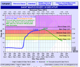
Flood warning information is also available directly to the public via the National Weather Services Advanced Hydrologic Prediction Services (AHPS) website. The Advanced Hydrologic Predictions Services (AHPS) is the National Weather Service’s (NWS) frontline solution to provide improved river and flood forecasting and water information across America.
AHPS displays the magnitude and uncertainty of occurrence of floods or droughts, from hours to days and months, in advance. Among other things, information such as the flood forecast level and time of peak or crest, is provided through hydrographs as shown here. Expected impacts in the floodplain are also described for various flood stages at the gauge and values for conversion of gauge heights to NAVD elevations to allow comparison of expected elevations to the affected FIRM panel and the 1% annual chance flood elevations. See the example below.
In summary, where there are USGS gauges and NWS forecast points, AHPS can provide the public with more detailed and accurate answers to the following:
-
Which gauged streams are at or above flood stages? Where will flooding occur? (A map is shown with color coding to represent the different degrees of flooding.)
-
How high will the river rise and when is the peak expected? (A graph of stage verses time is shown with various flood levels noted.)
-
How high has the river flooded in the past? How low has the water in the river been? (A page is provided with historical information on river stages.)
-
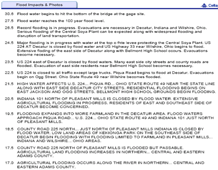
What areas and facilities are impacted at a given river stage? (A table of stages and description of impacts is provided. This river crest information can be used to analyze the “potential impacts” that such a crest might have as noted under “Flood Impacts & Photos”.)
-
What actual elevation does the river stage correspond to and how does that correspond to the Flood Insurance Rate Maps? (A page is provided giving this elevation information for each gauge.)
2008 MASTER PLAN ENHANCEMENTS
Continued upgrading of the early warning system technology in Fort Wayne and outlying communities should be pursued when upgrade capabilities are made available. Additional communities/organizations should also be contacted about becoming a regional partner. Suggested entities include DeKalb County Department of Homeland Security, the Towns of Leo, Cedarville, and New Haven, and the DeKalb Eastern School Corporation (due to location of a school in the St. Joseph River floodplain).
To aid in informing appropriate people in a timely manner, it is also recommended that more people sign up for the USGS river gauge notification when the stage reaches specified elevations so that appropriate actions can be taken. Suggested people who should take advantage of this are all EMA Directors, Floodplain Administrators, Planning Directors and other agency heads. These people also need to be made aware of the AHPS website and capabilities.
While there is sufficient stream gauge data for flood forecasting, additional gauges would provide data to be used for calibration of the hydraulic models used for Flood Insurance Studies and project analysis. Due to uncertainties and the lack of river gauges at the downstream ends of both the St. Joseph and St. Marys Rivers, it is recommended that future initiatives include pursuing the establishment of river gauges to more effectively monitor the stage / discharge of these two rivers at their respective downstream reaches.
Establishment of a gauge on the St. Marys River should be considered as a high priority due to uncertainties in the hydraulic model for the lower reach. The additional river gauge should be placed in the vicinity of the Main Street Bridge over the St. Marys River. (The Sherman Street Bridge would be the second choice for locating this gauge.) Establishment of this gauge would allow the hydraulic model to be calibrated to the actual gauge readings, making the model much more accurate and reliable. It is also located where it could provide important information about the amount of water leaving the basin via Junk Ditch to Little River. Funding of this gauge should be through a cooperative cost-share effort between Allen County / City of Fort Wayne Emergency Management Agency, City of Fort Wayne, Maumee River Basin Commission, and the United States Geological Survey - Indiana (USGS-IN). Once in place, it is recommended the City of Fort Wayne request the National Weather Service of northern Indiana establish this gauge site as a “forecast point” for the NWS’s Advanced Hydrologic Prediction Services (AHPS) web site.
Two other gauge locations could be added to the system. Establishment of these gauges would be a low priority. The first would be establishment of a gauge on the St. Joseph River. The additional river gauge should be placed in the vicinity of the Tennessee Avenue and State Street bridges since the furthest downstream gauge on the St. Joseph River is located much further upstream, approximately 1.1 miles linearly northeast of the Mayhew Road crossing. This existing gauge is considerably upstream of the downtown area and the Fort Wayne / Allen County Diking Project, making it impossible to calibrate the hydraulic model for the St. Joseph River to actual gauge data in the downstream reaches. Adding a gauge to the St. Joseph River would allow the hydraulic model to be calibrated to actual stream discharge / stage values, making it much more accurate and reliable. The second location would be along the Maumee River near one of the road crossings downstream of the Trier or Marsh Ditch confluences near the Platter Road crossing. This gauge would also provide information for calibrating hydraulic models and provide information about the contribution of the Trier and Marsh Ditch watersheds to downstream flooding.
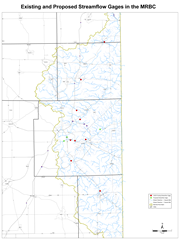
Funding for these gauges should be similar to that of the recommended St. Marys River gauge, though a cooperative cost-share agreement. Once in place, Allen County or the City of Fort Wayne should request the NWS to establish this gauge site as a “forecast point” for its AHPS website too. The locations of these proposed streamflow gauges are compared to the existing gauges as shown in the following exhibit:.
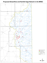
It is also recommended that three additional rain gauges be added to the network. The northern part of the St. Joseph River basin has a sparse number of rainfall gauges. Addition of a gauge in northwest DeKalb County and Steuben County near the state line would aid in identifying how widespread a particular rainfall event is over the St. Joseph River basin. This would aid in the forecast efforts along the St. Joseph River. Another gauge is recommended just southeast of Fort Wayne in the Houk Ditch/Trier Ditch watershed area. These streams, while smaller than the three main rivers, have significant floodplains. While advance warning is not as feasible on these smaller streams, the rain gauge would still provide information as to the severity of flooding that could be expected and the amount of resources that may be needed in these areas. This could be especially important during intense rainfall events that cover a smaller area and don’t result in flooding along the major streams. Other smaller streams in the basin appear to have a rainfall gauge near to them for such forecasting or have much smaller floodplains. A map showing the recommended general locations is shown in the following exhibit.
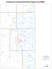
If the proposed rainfall and stream flow gauges were added to the network, the rain and stream gauge network would be as shown in the following exhibit:
RECOMMENDATIONS
The MRBC should:
-
Contact additional communities/organizations about becoming a regional partner in the City of Fort Wayne’s Early Flood Warning System. Suggested entities include but are not limited to DeKalb County Department of Homeland Security, the Towns of Leo, Cedarville, and New Haven, and the DeKalb Eastern School Corporation (due to location of a school in the St. Joseph River floodplain).
-
Assist the USGS in publicizing the ability to sign up for the USGS river gauge level notifications. Registration for this capability can be done by contacting the USGS. Those who should be informed of this capability include all EMA Directors, Floodplain Administrators, Planning Directors and other agency heads.
-
Ensure all EMA Directors, Floodplain Administrators, Planning Directors and other agency heads are aware of the AHPS website capabilities and the USGS gauge flood level automatic warning capabilities.
-
Establishment of a gauge on the St. Marys River in the vicinity of the Main Street Bridge should be pursued with a cooperative funding agreement between Allen County/City of Fort Wayne Emergency Management Agency, City of Fort Wayne, Maumee River Basin Commission, and the United States Geological Survey - Indiana (USGS-IN). Once established, this gauge should become a part of the NWS AHPS flood forecast site.
-
Continue funding of stream gauges. The Indiana Water Monitoring Council (InWMC), an organization established in 2008, is a representative body of water monitoring professionals and volunteers dedicated to increasing the use and value of water monitoring information statewide, by maximizing resources through improved communication, coordination, data sharing, and collaboration. One of the many objectives of this organization is to promote funding of stream gauges in Indiana. MRBC should become a member of and closely work with this organization to further its goals.
-
Add three additional rain/snow gauges to the network, one in northwest DeKalb County, one in the southeast portion of Steuben County near the State line, and one just southeast of Fort Wayne in the Trier Ditch or Houk Ditch watershed. Recommended approximate locations are provided on a map earlier in this chapter.
![]()
Other Information
![]()
THIS SITE IS BEST VIEWED IN MICROSOFT INTERNET EXPLORER 6.0 OR HIGHER