CHAPTER III-7
VOLUNTARY MITIGATION & FLOOD PROTECTION PROJECTS
INTRODUCTION
Recent history has repeatedly shown the high economic, social, and emotional costs associated with flooded homes, fields, businesses, and infrastructure. Consequences reach beyond just the immediate interruption of activity and potential for emergency services to the cost of repair, clean up, emotional toll, lost property/production, etc. Flooded homes and businesses cost everyone.
Structural methods, such as flood control ponds, diversions, and levees, and non-structural methods, such as acquisitions and retrofitting, have been successfully and unsuccessfully used nationwide to protect people and property from flood damage. MRBC seeks to go beyond just reducing the probability of flooding to also reduce the negative consequences of flooding when protection levels are exceeded. The 1995 Master Plan recommended a combination of these measures to protect residents and property in the basin. Since the writing of the 1995 Master Plan, several projects have been initiated and/or completed within the basin. Allen County’s Flood Insurance Rate Map (FIRM) delineations of flood hazard areas were revised as a result of Allen County providing better available data in the form of two-foot topographical mapping. DeKalb County’s FIRMs were updated in 2006 to digital FIRMs with database attributes for use with DeKalb County’s Geographic Information System (GIS). New digital FIRMs incorporating new approximate studies or floodplain redelineations have also been completed for Adams County and are in the process of being completed for Noble and Steuben Counties. This was a drastic improvement from the old Flood Hazard Boundary Maps. These improvements have created a need to update, expand, and reprioritize the 1995 Master Plan recommendations as a result of better available data.
This Master Plan Update provides an opportunity to revisit the 1995 Master Plan recommendations, evaluate their implementation, measure their success to reduce flood losses, and make revisions/additions to further the MRBC goals. It also assists communities that participate in the Community Rating System (CRS) by satisfying the requirement to inventory floodprone structures.
1995 MASTER PLAN REVISITED
Within the studied streams of the Maumee River Basin, the 1995 MRBC Master Plan identified 4,900 structures located within the 1% annual chance floodplain. Approximately 3,190 of these structures were to be protected by the US Army Corp of Engineers diking project in Fort Wayne. Of the 1,710 structures remaining, 278 were recommended for buyout, 1,100 recommended for floodproofing, 179 structures were to be protected by levees and floodwalls along small portions of the St. Marys River and Junk Ditch in Fort Wayne, and 153 other structures were to be protected by plans considered by the City of Fort Wayne at the time. These recommendations were based on a reach by reach damage assessment study and cost analysis of various proposed structural and non-structural alternatives. Throughout the basin, the total capital cost required to address the property damages was estimated at about $30.7 million.
MRBC AND MRBC COMMUNITY ACCOMPLISHMENTS
In January 1996, MRBC developed a Floodproofing Cost-Share Assistance Program. This document was prepared in order to establish the program details, technical guidelines for retrofitting floodprone structures, eligibility, and how to apply for the MRBC’s financial assistance. A copy of this guidance document is provided in Appendix D. A link to the document is also provided below.
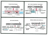
In September 1996, MRBC developed a Voluntary Buyout Cost-Share Assistance Program. This document was prepared in order to establish the program details, eligibility, and how to apply for the MRBC’s financial assistance. A copy of this guidance document is provided in Appendix E. A link to the document is also provided below.
Allen County and City of Fort Wayne
As of July 2008, 9 structures have been retrofitted and 110 structures have been purchased or are in the process of being purchased and demolished in Allen County. These acquisitions have eliminated flood damage to individual structures as well as to whole neighborhoods. They have eliminated the need for flood fight efforts during a flood and cleanup and damage assessment after the flood. Temporary flood storage in the form of open space has also been restored. This open space can now be used for recreational purposes and natural area restoration.
In addition, the following projects are being pursued or have been completed for the purpose of protecting flood prone structures.
St Marys River, Park Thompson/Waldron Circle Project (City of Fort Wayne funding): buy row of homes along the river and the ARC building. Construct berm to protect approximately 20 other homes in the neighborhood.
Fairfield Ditch (potential Corps of Engineers project): conceptual level report has been completed recommending construction of a backwater control structure at Bluffton Road and construction of two levee/wall reaches to protect approximately 70 homes and 3 businesses.
St Marys River, Woodhurst Levee (City of Fort Wayne funding): construct flood control levee to protect approximately 90 homes, a school, and a church
St Marys River, Southfair Court & Kenosha Boulevard project (City of Fort Wayne funding): construct sandbag replacement berm to protect about 5 homes instead of sandbagging for frequent flood protection.
St Marys River, Berry Thieme floodwall (City of Fort Wayne funding): this floodwall project will be dropped in favor of placing “emergency” clay berms during a flood due to stiff opposition to the floodwall, likelihood of seepage under the floodwall, and the difficulty in acquisitions due to the “Historic Designation of the neighborhood.
Spy Run, Eastbrook/Westbrook (City of Fort Wayne and federal money): Homes have been bought and demolished along Westbrook and a berm will be constructed to provide protection along Edgehill. Homes along Eastbrook will be bought out and the State Street bridge raised (reducing expected water surface elevations in the vicinity upstream).
St Marys River, Winchester Road (City of Fort Wayne funding): acquire and demolish one row of houses then construct sandbag replacement berm at the 1% annual chance flood elevation to protect around 6 homes.
Lawrence Drain, Times Corner culvert replacement (City of Fort Wayne project): reduced Base Flood Elevations (BFE) in the reach upstream of Jefferson Boulevard. If a Letter of Map Revision (LOMR) is pursued based on this culvert replacement, three apartment buildings, a commercial area, and a retirement home could be removed from the 1% annual chance floodplain.
Spy Run, channel improvement between Production Drive and Coliseum Boulevard (City of Fort Wayne project): proposed project that could remove approximately 8 businesses from the 1% annual chance floodplain and significantly reduce and/or eliminate the flooding potential for the 10% annual chance flood.
St Marys River, earthen dike constructed along the east bank of the river near Pauline Street (Reach 3 (E3SM) in the 1995 Master Plan): The berm was constructed almost to the 1% annual chance flood elevation. During a flood situation, the City ties this dike to high ground by building a temporary barrier dike in the middle of a parking lot in the southern portion of the reach.
St. Marys River, earthen dike (“Vesey Dike”) constructed along the west bank of the river generally between Nuttman and Gruber Avenues (Reach W7SM in the 1995 Master Plan) to an elevation below the 1% annual chance flood elevation with the intent to add sand bags if needed per the City of Fort Wayne’s plans.
In the process of selecting and designing projects, the City of Fort Wayne has also recognized the need to minimize the impact of the planned projects and has incorporated items such as compensatory storage and rain gardens to better manage stormwater runoff.
Adams County
Description of accomplishments to be added later as part of the future phases of the MRBC Master Plan update.
DeKalb County
Description of accomplishments to be added later as part of the future phases of the MRBC Master Plan update.
Noble County
Description of accomplishments to be added later as part of the future phases of the MRBC Master Plan update.
Steuben County
Description of accomplishments to be added later as part of the future phases of the MRBC Master Plan update.
2008 MASTER PLAN ENHANCEMENTS
Since the 1995 Master Plan, additional/revised identification of flood risks has been completed, technology to enable better identification of floodprone structures has become available, and the acquisition and flood protection projects described under MRBC and MRBC Community Accomplishments have removed several buildings from the list of floodprone structures. This Master Plan update provides an opportunity to more accurately identify remaining floodprone structures and reevaluate plans and priorities for mitigation.
An extensive examination of vulnerability of each community, including critical facilities, number and type of buildings subject to each hazard, and the magnitude of damages within the MRBC jurisdiction area, has recently been completed by MRBC as part of five Multi-Hazard Mitigation Plans for Allen, Adams, DeKalb, Noble, and Steuben Counties in Indiana. The inventory of data and conclusions from the noted plans were considered and incorporated, as appropriate, within this Master Plan Update. To avoid redundancy of including the noted detailed information directly in this report, the reader is directed to each of these documents through the following links:
- Allen County MHMP (13 MB)
- Adams County MHMP (7 MB)
- Adams County MHMP (2012 Update) (7 MB)
- DeKalb County MHMP (8 MB)
- Noble County MHMP (7 MB)
- Steuben County MHMP (9 MB)
As part of this Master Plan update, an inventory of individual floodprone structures in each County was created. The inventory was based on best available Flood Insurance Rate Maps (FIRMs), Letter of Map Revision (LOMR) data, or Indiana Department of Natural Resources (IDNR) Floodplain and Regulatory Assessment (FARA) elevations as a source for Base Flood Elevations (BFEs). Preliminary studies are being done for the MRBC on Flatrock Creek, Black Creek and Hoffman Ditch; results of these studies were also used in place of the current FIRM Zone A delineation. The lowest adjacent grade (LAG) at a structure was determined from topographic mapping (best available data) or actual surveyed elevations. The difference between the BFE and the LAG was used as the depth of flooding for each structure. The flood zone that applied to each structure was also noted (Zone AE, floodway, outside 1% annual chance floodplain but within 0.2% annual chance floodplain, outside 0.2% annual chance floodplain, Zone A). Information was also obtained to identify which structures have been designated as repetitive loss structures under the National Flood Insurance Program (NFIP).
Structures afforded some protection by flood control structures were included in the flood prone structure inventory. For the purposes of prioritizing future mitigation plans, it was assumed that the protection already provided by the existing and proposed by planned levees/berms as described in the MRBC and MRBC Community Accomplishments section are completed and protect the structures behind the levees/berms during the 1% annual chance flood. Protected structures were not removed from the floodprone structures list but were not considered for acquisition or further structural protection. Structures already in the acquisition process were also counted as already purchased.
In addition, structures that were identified in the floodway but which were on high ground above the Base Flood Elevation (BFE) were designated as not needing mitigation (based on the assumption that the floodway had been drawn in error since less detailed mapping was available when the floodway delineations were made).
It should be noted that while every effort was made to identify each floodprone structure, some may have been missed and some may have been constructed after the inventory was taken. The identification of floodprone structures can be updated as better data becomes available.
Once the inventory of floodprone structures was created, the proposals for floodprone structure protection from the 1995 Master Plan were reevaluated and new alternatives investigated. This included large and small scale structural measures, voluntary acquisition, retrofitting, or no action. A discussion of each of the options follows.
Large Scale Structural Measures
Large Scale Structural Measures would include relatively long reaches of levees or channel improvements such as those improvements often associated with U.S. Army Corps of Engineers (USACE) projects. Several such measures were investigated for the 1995 Master Plan but were not recommended for implementation. In the 1995 Master Plan, acquisitions and retrofitting were the selected alternatives for most of the reaches. Small scale structural measures were also selected for a few reaches. Even though large scale structural measures were considered but generally not recommended in the 1995 Master Plan, they are revisited for this update to see if circumstances have changed in a way to make any of the options desirable or if some degree of the measure has merit for decreasing the potential for future flood damages. Such measures would be evaluated in regards to their impact on other properties and selected or formulated in such a way as to cause no adverse impact.
The following is an updated discussion of each short listed large scale structural alternative from the 1995 Master Plan.
St Marys River major retention/detention basin upstream of Decatur
To be addressed when additional data is available as part of the future phases of the MRBC Master Plan update.
Yost Levee Removal/Bypass Channel
To be addressed when additional data is available as part of the future phases of the MRBC Master Plan update.
St. Marys River Overflow Paths (40% & 20% Trier Ditch Cutoff, Junk Ditch Bypass)
In the 1995 Master Plan, three alternatives were investigated for increasing the St Marys River overflow paths in order to reduce flood damages. These alternatives included construction of two different sized cut-off channels that would carry 40% or 20% of the 1% annual chance peak discharge of the St Marys River along Houk Ditch and Trier Ditch to the Maumee River, bypassing the junction of the three rivers. The other alternative called for increasing the existing capacity of the St Marys River overflow to the Wabash River via Junk Ditch and Little River. The consideration was to allow 30% of the St Marys River 1% annual chance flood flow to “escape” via Junk Ditch.
Although these alternatives were not selected, the evaluation of them showed that these paths have been used by floodwaters in previous flood events. According to a 1974 USACE report, 20% of the St Marys River 1% annual chance flood flow is what flowed through the Trier Ditch cutoff during the 1913 flood. That same study, as well as an analysis by SEG Consultants in 1994, found that the overflow path capacity would be half of that should the 1913 flood have occurred under the conditions at the time of the study. Also according to the USACE 1974 study, approximately 30% of the St Marys River 1% annual chance flood discharge flowed from the St Marys River to the Wabash River via Junk Ditch and Little River in 1913. The report indicated that at the time of the USACE study, obstructions in the floodway of Junk Ditch had reduced the capacity from the 1913 value of 5,000 cfs to 3,300 cfs.
These overflow paths have been used in past flooding but do not always perform as expected due to uncertainties in the flood elevations on the St Marys River and varying backwater conditions and/or timing of rainfall concentrating on various tributary watersheds. Based on this observation, every effort should be made to keep these St. Marys River overflow paths functioning and clear of encroachments and obstructions so that future flood stage conditions are not made worse along the St. Marys River. It is also important to note that as a result of uncertain and varying performance of these overflow paths, there are more uncertainties in determining the expected St. Marys River 1% annual chance flood elevations than that expected typically. Therefore, consideration of larger than usual freeboard is strongly suggested for structures along the St. Marys River corridor.
Along the Junk Ditch, the floodplain has been delineated and acquisition of structures in the floodplain has begun and should continue in order to keep that overflow path available for flood waters and remove structures from harm’s way. No additional development should take place in the Junk Ditch/St Marys River overflow floodplain unless it does not constitute any obstruction of the existing flow area, does not significantly decrease flow to the Little River wetlands, and does not significantly increase flow to Little River.
Along the Houk Ditch/ Trier Ditch overflow path there is currently no mechanism in place to prevent this overflow path from losing additional capacity. If additional development or raising of road elevations occurs in the overflow path, not only will additional structures and their inhabitants be in danger due to their location in a floodplain but additional structures and people will be impacted by the increase in water surface elevations along the St Marys River as well.
To prevent the further reduction of the capacity of this “emergency spillway” for the St Marys River, the present condition of the Houk Ditch/ Trier Ditch overflow path needs to be evaluated, a path which can be preserved for the necessary overflow path needs to be determined, the feasibility of designating this path as an Impact Area needs to be investigated, feasibility of creating a pilot channel in the saddle area along with additional measures to prevent adverse impacts to properties along the path needs to be investigated, and other measures necessary to prevent the loss of the “emergency spillway” need to be determined.
Cedar Creek Reservoir
To be addressed when additional data is available as part of the future phases of the MRBC Master Plan update.
Small Scale Structural Measures
Where a structural measure had merit but some of the pitfalls of a large scale structural measure were too great, small scale structural measures were considered in the 1995 Master Plan. These included relatively short reaches of levee/berms that could protect a large number of structures. Except for freeboard requirements, the flood control work suggested was to be designed and constructed according to the IDNR and FEMA specifications for the flood control works. At most, only 1 to 2 feet of freeboard would be used to account for any potential embankment settlement or inherent inaccuracies involved in the 1% annual chance flood stage predictions in an urbanizing watershed. By not meeting FEMA's minimum 3 foot freeboard criteria, the protected structures would be disqualified from any potential waiver of the Federal requirement to purchase flood insurance. This policy was advocated to significantly reduce the 1% annual chance flood damages while avoiding the appearance of providing a false degree of security to the protected structures. The flood insurance requirement is a constant reminder that floods greater than the designed level of protection do and will happen and that levee systems are not fail proof.
City of Fort Wayne plans also included small scale structural measures consisting of constructing a low berm that could provide protection for the more frequent flood events or serve as a foundation for additional sandbagging during higher flood events. In Fort Wayne, such structures have been combined with acquisitions to provide protection to neighborhoods.
Whenever a small scale structure is used, it, should be evaluated for no adverse impact in regards to increasing erosion, discharge, or stage in other unprotected areas. The structure should be designed to function safely with as little maintenance as possible. As part of constructing the structure, options to provide an increase in the capacity of the area to store runoff should be investigated and implemented as much as feasible. Small scale structural measures constructed by MRBC communities were noted previously. Following is an updated discussion of each of the additional short listed small scale structural alternatives from the 1995 Master Plan.
St Marys River, west bank generally from Hale Avenue to SR 14 (Reach 14 (W6SM) in the 1995 Master Plan)
Preliminary studies in the 1995 Master Plan seemed to indicate that the 1% annual chance flood damages in this reach could be eliminated by constructing approximately 3,200 ft of protection (consisting of floodwalls, levees, Taylor Street closure structures, and internal drainage measures) along the St. Marys River. A detailed hydraulic analysis to define the degree to which this area is used as a natural St. Marys River overflow path was noted in the 1995 Master Plan as a pre-requisite for such a proposed project. Allowance had also been given for an additional 3,200 feet of 2-feet berm alongside the Norfolk & Western Railroad embankment forming the western boundary of the reach to ensure that flow from Junk Ditch would not flood the reach from the west side.
In recent discussion with Fort Wayne officials, it was found that this area does not experience flooding problems. No immediate action is therefore recommended in this area based on this observation. It should, however, be noted that in floods near the 1% annual chance event and above, this area may serve as an additional overflow path to Junk Ditch and the Little River. Development in this floodplain area should be allowed only when it does not interfere with the present potential capacity to convey St Marys River overflow to Junk Ditch.
Junk Ditch, east bank between RR near Jefferson Boulevard and RR near Edgerton (Reach 47 (E1JD) in 1995 Master Plan)
Along Junk Ditch in this reach are several businesses on both sides of Jefferson Boulevard. Jefferson Boulevard has to be closed during major floods due to Junk Ditch high water created by the St. Marys River overflow. Because of the closure of Jefferson Boulevard during floods and the type of businesses involved, it is unlikely that any type of retrofitting will prevent these businesses from being closed due to floods. At the time of the 1995 Master Plan, the best solution for this reach appeared to be the construction of an approximately 2,000-foot long levee/floodwall between two Conrail railroad embankments with provisions for internal drainage (& closure structure on Jefferson Boulevard).
To be a viable option, accurate hydraulic modeling for the Junk Ditch - St. Marys River system, currently not available, would be needed to determine the hydraulic soundness of this alternative. Sufficient floodplain storage and area to pass the full overflow discharge without increasing water surface elevations downstream or upstream would need to be provided in a selected design.
A recommended variation on this alternative would be to split the area into two sections with two different approaches. The structures northeast of Jefferson Boulevard are inundated more frequently. One of them, the largest, is also a Repetitive Loss structure and has gone out of business. The City has expressed interest in purchasing the property and incorporating some wetlands and wildlife areas to revert the area to a natural setting. Grant money or private funds are being sought for this project. It is suggested that these structures be bought out and Jefferson Boulevard be raised. The open space area created by buying out the structures could have a variety of uses as traffic enters the downtown area and could provide additional flood storage capacity for the St Marys River overflow. Traffic flow would benefit by the availability of use of Jefferson Boulevard during floods and the raised Jefferson Boulevard could be a main component of providing flood protection to the businesses on the southwest side that experience shallower flooding than those on the north, allowing them to still be in business during flood events.
Discussion of Additional Structural Alternatives Not Considered in the 1995 Master Plan
Allen County
In expanding this analysis to streams other than the main streams, three additional reaches with a concentration of potential at-risk structures were noted.
- Bullerman Ditch (near the confluence with the tributary near Spanish Trail upstream of Trier Road).
- On the south side of the Maumee River between Pluma and Parrot Roads.
- The Ross Michaels neighborhood between Superior Street and the St Marys River.
Due to the junction of tributaries and the area over which the structures are distributed, a levee to protect the Bullerman Ditch area would be especially long and expensive compared to the number of structures it could protect. It is therefore not recommended.
Although along the south side of the Maumee River there is a concentration of flood prone structures, there is not a high enough concentration based on the costs for similar areas in the 1995 Master Plan analysis to be cost effective for structural measures. Structural measures are therefore not recommended for this area.
In the Ross Michaels area, the City of Fort Wayne has indicated that they could receive benefit from the purchase of two structures north of the platted east west alley through the neighborhood and the construction of a flood fight berm along the alley. This scenario would move current flood fight efforts back further from the river allowing more conveyance area for flood waters and provide a permanent base for sand bagging efforts when needed for the remainder of the neighborhood. This option is therefore recommended.
Adams County
Discussions to be added later as part of the future phases of the MRBC Master Plan update.
DeKalb County
Discussions to be added later as part of the future phases of the MRBC Master Plan update.
Noble County
Discussions to be added later as part of the future phases of the MRBC Master Plan update.
Steuben County
Discussions to be added later as part of the future phases of the MRBC Master Plan update.
Voluntary Acquisition, Voluntary Retrofitting, or No Action
Based on the findings of the 1995 Master Plan, the vast majority of floodprone structures in the basin will be better suited to acquisition or retrofitting. To help identify these structures, a categorization system was created using data from the floodprone structure inventory. It should again be noted that due to the limited accuracy of available information for determining lowest adjacent grade of buildings and the lack of information about the type of structure for this level of analysis, structures may or may not actually experience the degree of flooding noted in the inventory.
This categorization is meant as a first step in identifying target areas for potential mitigation efforts. Local communities can use this screening to narrow down the field of potential required mitigation efforts and set initial priorities. These priorities can then be adjusted as needed as more detailed information is obtained for each specific situation. For instance, in areas where structures along smaller tributaries are given high priority due to their depth and location in a floodway, and the floodway determination is based on older hydraulic modeling, the community may want to have updated hydraulic modeling performed to confirm or revise the floodway limits before committing to pursue voluntary acquisition of those structures. Communities should also note that any historical structure, due to Federal and/or State regulation, may be difficult to acquire even if the owner is a willing seller. Such historical structures were not identified as a part of this categorization.
Structures were grouped into categories based on the estimated depth of flooding and the FIS flood zone in which they were located. Following is a listing and description of each category:
Category A.
|
Structures in the floodway with expected flooding depth of 2 feet or more. |
Category B.
|
Structures not in the floodway but with expected flood depth of 3 feet or more. |
Category C.
|
Structures in the floodway with expected flooding depth of less than 2 feet. |
Category D.
|
Structures not in the floodway but with expected flooding depth of less than 3 feet. |
Category E.
|
Structures shown outside the 1% annual chance floodplain but within the 0.2% chance floodplain, unless the LAG is at or below the BFE. |
Category F.
|
Structures shown within an approximate study zone (Zone A). |
Category G.
|
Structures shown within the 1% annual chance floodplain but with LAG above the BFE. |
Category H.
|
Structures currently shown outside 1% annual chance floodplain, but with a LAG at or below the BFE. |
Category I.
|
Other structures that may have been originally included in the database due to their proximity to designated flood hazard areas, but with a LAG now determined to be above the BFE. |
A summary showing the number of structures falling within each category, by jurisiditional area, is shown below.
Jurisdiction |
Category |
|||||||||
A |
B |
C |
D |
E |
F |
G |
H |
I |
TOTALS |
|
New Haven |
4 |
10 |
7 |
45 |
51 |
0 |
1 |
57 |
28 |
203 |
Fort Wayne |
68 |
450 |
77 |
1084 |
1139 |
19 |
46 |
268 |
263 |
3414 |
Allen County (remainder) |
56 |
55 |
45 |
283 |
210 |
150 |
30 |
240 |
334 |
1403 |
Totals |
128 |
515 |
129 |
1412 |
1400 |
169 |
77 |
565 |
625 |
5020 |
Based on the expected degree of flood risk assigned to each structure according to each category identified above, discussions with the steering committee, and MRBC experience, the following actions are recommended with the noted priority.
-
High Priority Mitigation Projects: Pursue voluntary acquisition and remove buildings exposed to the highest flooding risks. Structures in Category A are well suited to being given highest priority in voluntary acquisition plans. Presence in the floodway indicates that these structures are in an area of higher velocity floodwaters with depths significant enough to cause damage. Structures in this category would be at the highest risk of receiving the most damage and having the most potential for exposing the residents to physical harm. Additionally, repetitive loss structures that fall in this priority class should be given higher priority. Also included in this category are structures that have been determined by the community or MRBC to be a high priority candidate for voluntary acquisition due to 1) proximity to a group of contiguous Category A structures or 2) inclusion in the community’s flood fight or open space plans.
-
Medium Priority Mitigation Projects: Pursue voluntary acquisition and remove buildings exposed to significant flooding risks. Structures in categories B and C are included in the next priority class for voluntary acquisitions due to 1) significant flood hazards created by being in an area with high flooding depth but lower velocity currents (Category B) or 2) by being in an area with high velocity currents but lower flood depth (Category C). Additionally, repetitive loss structures that fall in this priority class should be given higher priority.
-
Low Priority Mitigation Projects: Offer voluntary retrofitting assistance for buildings exposed to relatively low flooding risks. Category D structures are theoretically exposed to shallower flood depths and should be considered for retrofitting, provided flood free access is available to the structure. However, if reasonably safe flood free access is not available, a structure should be considered for voluntary acquisition. Additionally, the remaining repetitive loss structures not already included in priority classes 1, 2 or 5 are included in this class and should also be given higher priority. Also included in this category are structures that, based on the community’s knowledge and experience, should be given lower priority for pursuing voluntary acquisition.
-
Structures Needing Further Studies: Determine appropriate mitigation actions (if any) for structures in Category F, G, and H once additional detailed floodplain studies are performed per recommendations found in the Flood Hazard Mapping section of this Master Plan update.
-
Structures Protected or Proposed to be Protected by a Local Structural Flood Control Measure: Monitor the progress, success, and sustainability of existing and planned structural flood protection measures and flood fighting berms in reducing the flood risks for buildings being protected by these structural measures. These include structures/buildings in Categories A through D that are believed to be protected by the community against 1% annual chance flooding. Although no acquisition or retrofitting measures are currently recommended for these structures, more intensive education and outreach efforts are recommended for these areas to caution residents against a false sense of security that is often associated with structural flood protection projects. As situations change or plans for implementation of proposed structural flood control measures are modified, the structures in this action class would need to be re-evaluated for possible transfer to other classes.
-
No Immediate Action Required: Monitor the occurrence and extent of any flooding impacts for structures for which no action is recommended per community’s request. These include structures in Category A through D that, based on the community’s knowledge and experience, would not require a mitigation action at this time. As situations change and more experience is gained, the structures in this action class would need to be re-evaluated for possible transfer to other classes.
-
Others: No actions are currently suggested for structures in Category E. However, MRBC may provide retrofitting assistance for these structures when requested by the property owner. Also, no actions are currently suggested for structures in Category I.
A summary of the number of structures in the Allen County area included within each Class are provided in the table below.
Jurisdiction |
Priority Rank |
|||||||||
1 |
2 |
3 |
4 |
5 |
6 |
7 |
Acquired |
Retrofitted |
TOTALS |
|
New Haven |
4 |
17 |
45 |
58 |
0 |
0 |
79 |
0 |
0 |
203 |
Fort Wayne |
223 |
196 |
684 |
251 |
555 |
2 |
1386 |
109 |
8 |
3414 |
Allen County (remainder) |
54 |
97 |
275 |
404 |
0 |
28 |
543 |
1 |
1 |
1403 |
Totals |
281 |
310 |
1004 |
713 |
555 |
30 |
2008 |
110 |
9 |
5020 |
The prioritization of mitigation projects is meant to provide communities with a tool to prioritize their acquisition opportunities and maximize the benefits from the available acquisition funds. As a community makes its selections for acquisition areas, it should be remembered that a structure currently in the Medium or even the Low priority class should be considered for high priority acquisition if it is located in an area where most of the structures will be bought out and it doesn’t make sense to leave 1 or 2 structures alone in the area. Focus areas should be targeted for acquisition, instead of haphazardly pursuing individual acquisitions in various neighborhoods, in order to more quickly reduce the number of areas where flood fight activities are needed and reduce the length of time a neighborhood is disrupted.
In selecting acquisition areas, consideration should also be given to coordination with other departments within a community/county to minimize costs by accomplishing multiple objectives at the same time. Examples would be park projects or road relocation/improvement projects that may require acquisition of structures as well. A mechanism for knowing when a structure in one of the mitigation priority classes is being foreclosed or going out of business would also increase the awareness of timely acquisition opportunities.
The City of Fort Wayne has had the foresight and ability to establish its own funding source for acquisitions in addition to federal grant funds; this has greatly accelerated the reduction of potential flood damages. The local initiative to create a funding source to accelerate acquisitions is a valuable tool in reducing flood damages and should be continued, as well as implemented in more communities as feasible. Federal grant writers and local fund administrators should coordinate efforts that allow them to compliment each other and accomplish more for the dollar. For instance, one area may be qualified to easily receive federal dollars in which case, the local fund administrator would not need to focus on that area. Or, local dollars may be able to purchase the last remaining structures in an area for which federal dollars can’t be obtained. Many factors affect the efficiency of acquisitions so continuous coordination efforts are recommended between local fund administrators and the federal grant writers to obtain the most benefit for the money invested.
The following exhibit highlights structures in various mitigation priority classes as well as those structures that have been (or are in the process of being) purchased, demolished, or retrofitted.
Estimated acquisition costs were determined based on the assessed property value plus 20% for contingencies/allowance to account for demolition, appraisal, title search, closing costs, and other administrative costs. Costs for retrofitting were estimated based on the MRBC program allowable cost-share limits of up to $5,000 for properties located within the 1% annual chance floodplain or up to $2,500 for properties located within the 0.2% annual chance floodplain. The following table provides a summary of estimated costs for the proposed High, Medium, and Low Priority mitigation projects within the MRBC jurisdiction.
JURISDICTIONAL AREA |
TOTAL NUMBER OF STRUCTURES AND ESTIMATED MITIGATION COST |
|||||
High Priority |
Medium Priority |
Low Priority1 |
||||
# Str |
Estimated Cost |
# Str |
Estimated Cost |
# Str |
Estimated Cost |
|
Adams County |
TBD2 |
TBD2 |
TBD2 |
TBD2 |
TBD2 |
TBD2 |
Allen County (remainder) |
54 |
|
97 |
|
275 |
|
| Fort Wayne | 223 | 196 | 684 | |||
| New Haven | 4 | 17 | 45 | |||
DeKalb County |
TBD2 |
TBD2 |
TBD2 |
TBD2 |
TBD2 |
TBD2 |
Noble County |
TBD2 |
TBD2 |
TBD2 |
TBD2 |
TBD2 |
TBD2 |
Steuben County |
TBD2 |
TBD2 |
TBD2 |
TBD2 |
TBD2 |
TBD2 |
Wells County |
TBD2 |
TBD2 |
TBD2 |
TBD2 |
TBD2 |
TBD2 |
TOTALS |
TBD2 |
TBD2 |
TBD2 |
TBD2 |
TBD2 |
TBD2 |
- The estimated cost reflects the maximum MRBC program cost-share/contribution only. Remaining costs will vary depending on methods selected by owners. Also, estimated costs do not include potential acquisition projects that may have been determined to be low priority at this time for various reasons.
- To be determined later in the future phases of the MRBC Master Plan update
RECOMMENDATIONS
The MRBC should:
-
Pursue funding and encourage the voluntary acquisition of structures identified in High, Medium, and Low Priority mitigation project classes. Continued removal of structures from the floodplain eliminates the need for flood fight efforts in these areas, restores floodplain storage, eliminates worries about access to these areas and the need for evacuation during a flood, eliminates the need for clean up or damage assessment of the areas after a flood, eliminates emotional and financial toll on residents, and opens up a variety of possibilities for other uses for that land. Some possible uses for this land are water quality buffers, habitat restoration areas, outdoor art exhibits, outdoor concert areas, community park areas, perhaps ground for community nursery to provide plants for use in City projects, test areas for “green” parking lot innovations, parking areas near bus and train stations, or overflow parking for community events.
-
Encourage and assist in the education of the public that while structural measures have a role to play in providing protection, it must be remembered that the level of protection will at some point be exceeded. Real risks must be kept in mind and evacuation or other such plans to deal with that point in time must be in place before the event occurs.
-
Continue to encourage and facilitate the acquisition of structures in the Junk Ditch floodplain and recommend that no more development be allowed in the Junk Ditch/St Marys River overflow floodplain unless it does not constitute any obstruction of the existing St. Marys overflow area.
-
Recommend consideration of the modified proposal for the reach of Junk Ditch between Edgerton Road and Jefferson Boulevard including the acquisition of properties in the reach northeast of Jefferson Boulevard and raising Jefferson Boulevard in conjunction with retrofitting of the structures southwest of Jefferson Boulevard. The impact of raising Jefferson Boulevard on flood flows to or from St Marys River will need to be evaluated and designed so as to create no adverse impact.
-
Recommend consideration of acquisition and flood fight berm construction in the Ross Michaels neighborhood along the St Marys River near the junction of the three rivers.
-
Keep the structure inventory up to date. In order to do this, all MRBC community building departments will need to coordinate with their respective Floodplain Administrators regarding development in or near the floodplain to forward structure locations and LAGs (if available) to MRBC for input to the data base.
-
For any large or small scale structural measure that would be proposed in the future, MRBC should encourage the investigation of impacts on discharges, flood stages, storage capacity, and erosion effects. Such investigation may show that additional flow capacity needs to be added, upstream basins are needed to offset the increase in flow caused by the project, or compensatory storage needs to be created. Possible erosion impacts in other areas may also need to be addressed.
Planned overtopping of flood protection projects should also be considered in the design so that when the design level is exceeded, flooding is controlled and directed to minimize damages. Such overflow capabilities would also provide some relief for upstream and downstream properties.
Communities should be encouraged to look beyond the cost/benefit ratio in terms of environmental, social, and economic terms and consider the public safety cost. Structural measures will have a continual cost associated with them for repair, maintenance, and emergency actions. -
Continue to help educate communities and the public that any existing or proposed large or small scale structural measure will at some time in the future experience an event greater than it was designed to withstand. Adequate consideration of how that will impact people and property should be taken into consideration when choosing to depend on such an alternative. Evacuation plans or emergency action plans should be developed and exercised yearly if the risks associated with constructing the structure for protection are deemed acceptable and the project is completed. Residents protected by structural measures should be notified annually that though they have a level of protection, there are still risks. To assist in this education process, signs could be posted in the area that would show people the level of flooding that could be expected should the protection measure fail.
-
Encourage the City of Fort Wayne to pursue a LOMR to reflect the floodplain changes resulting from the Times Corner culvert replacement project.
-
Assist communities in establishing a local funding mechanism for acquisition of flood prone structures.
-
Coordinate with local community officials and departments to leverage efforts that allow programs to complement each other and accomplish more for the dollar. For instance, one area may be qualified to easily receive federal dollars in which case, the local fund administrator would not need to focus on that area. Or, local dollars may be able to purchase the last remaining structures in an area for which federal dollars can’t be obtained.
-
Initiate an evaluation of a proposed Impact Area designation and additional measures along Houk Ditch/ Trier Ditch to maintain the bypass capacity for the St Marys River.
-
Encourage MRBC communities to reevaluate areas where “permanent” flood fight berms have been constructed in light of now available structure inventory data on expected flood depths. A contingency plan should be created to deal with potential loss of life and/or catastrophic economic losses should a constructed berm fail or be overtopped.
-
In an effort to prvent additional future mitigation needs, MRBC should encourage communities to avoid extensions of water and/or sewer lines to areas in the floodplain, unless the areas are properly protected from flooding and will not need flood fight efforts during a flood event.
-
Assist communities in obtaining updated studies to confirm or revise flooding limits, specifically for those tributaries with older hydraulic modeling. Updated studies would aid in confirming that high priority voluntary acquisition structures, as well as all other structures, are accurately categorized.
Links on this Page
![]()
Other Information
![]()
THIS SITE IS BEST VIEWED IN MICROSOFT INTERNET EXPLORER 6.0 OR HIGHER